Background and Trends
Walking is a basic human activity that has often been overlooked in the quest to build sophisticated transportation systems. Increasingly, the planning and development community, governmental agencies, educational institutions, employers, and the public at-large are recognizing the importance of providing adequate facilities for walking in all types of communities. We all want to live and work in places that are welcoming, safe, and enjoyable. We all want livable communities where we can walk, bicycle, recreate, and socialize.
Recent socio-economic and cultural trends also point to higher demands for walkable communities. Using the Walk Score, an online application using a 100 point scale that measures the walkability of any address, one study estimated that commercial properties with a Walk Score of 80 or greater were 6-54 percent more valuable than properties with a Walk Score of 20 or lower.1 Another study, using data from 1983 to 2008, found that fewer teens are getting driver’s licenses.2 Additionally, the 15-Year Status Report to the National Bicycling and Walking Study reported that trips for both walking and bicycling increased by 25 percent from 2001 to 2009.3
These trends indicate people’s desire to live and work in walkable places. Other trends related to walking and safety include:
- National initiatives, such as Complete Streets and Safe Routes to School, support the demand for more investment in pedestrian facilities and are examples of programs that support pedestrian facility development.3
- In 1991, Congress commissioned the National Bicycling and Walking Study, which outlined two national goals: to double the percentage of trips by biking and walking and to decrease the number of pedestrian and bicycle-related deaths by 10 percent.
- The 15-Year Status report released in May 2010 showed that, while the first goal of the initial National Bicycling and Walking Study has not yet been fully met, substantial progress has been made on both goals. In 2009, 11.9 percent of all reported trips were trips made on foot or by bicycle, coming close to the goal of a 15 percent mode share. In terms of fatalities to pedestrians and bicyclists, the number of pedestrian and bicycle-related deaths has decreased substantially since 1995, by more than 20 percent. By reducing pedestrian and bicyclist fatalities by more than double the original goal, it is clear that pedestrian (and bicyclist) safety has experienced progress in recent years.3Â
- In 2011, 4,612 pedestrians died in traffic crashes and roughly 69,000 were injured. While these totals are decreasing, pedestrian safety is an ongoing problem that should continue to be comprehensively addressed at all levels of government.4
- Unlike traffic volume data, which is routinely collected by state and local agencies, pedestrian volume data (which is critical to understanding pedestrian exposure) is unavailable in most locations in the U.S.
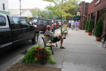 Design streets for people to use them and provide pedestrian facilities, such as sidewalks. Assume people will walk.
Traditionally, safety problems have been addressed by analyzing police crash reports and improvements have been made in response to crashes at specific locations or corridors. However, planners and engineers are realizing benefits from using research results to identify countermeasures that are most likely to reduce crashes and using public involvement strategies such as interactive public workshops, surveying pedestrians and drivers, and engaging law enforcement to identify safety problems before crashes occur. This approach helps to proactively identify locations for pedestrian safety improvements and involve citizens in the process of improving safety and mobility in their own communities. Planners and engineers have a responsibility to use the best available data and lessons learned from other practitioners to provide guidance to agencies, communities, and developers regarding best practices in pedestrian facility design and safety.
While there is still work to be done to improve pedestrian safety, access, and mobility, there have been tremendous strides made by many agencies and opportunities for many more agencies. Opportunities to improve conditions for pedestrians may arise in conjunction with other projects or as independent pedestrian projects. For example, sidewalks might be included in a roadway reconstruction project and an annual curb ramp program might be used to install ramps near transit stops. This chapter describes some of the basic principles of safely providing for pedestrians, that when applied lay the foundation for a transportation system that considers pedestrians and provides safer accommodations for all modes.
How Land Use Affects Pedestrians
Creating a walkable community starts with the very nature of the built environment: having destinations close to each other; siting schools, parks, and public spaces appropriately; allowing mixed-use developments; having sufficient densities to support transit; creating commercial districts that people can access by foot and wheelchair; and so on. The average walking trip is 0.7 mi (1.1 km).5 Â Dense, mixed-use developments, often supported by transit, can make walking an attractive option. When residents are separated from sites such as parks, offices, and stores, there will be fewer pedestrian trips because destinations are not easily accessible by foot. The connection between land-use planning and transportation planning is critical to safely and effectively accommodate pedestrians. The two figures below illustrate the relationship between distance to transit or other destinations and the decision on whether to walk.
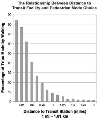 Source: Federal Transit Administration, Transit Cooperative Research Program, Transit and Urban Form, TCRP Report 16, 1996. Chart adapted from Figure 19.
  Source: Understanding Sustainable Transportation Choices: Shifting Routine Automobile Travel to Walking and Bicycling. R. Schneider, (dissertation) 2011. Figure 5.12.
Integrating land-use and transportation planning allows new developments to maximize opportunities for a safe and efficient system for pedestrians from the onset. In established communities, infill development can increase density and community viability. Changing zoning laws and development standards to encourage and promote mixed-use development and pedestrian connections such as sidewalks, accessible crosswalks, and shared-use paths, can also increase pedestrian safety and mobility.
Walking as a Mode of Travel
Whether building new infrastructure or renovating existing places, it should always be assumed that people will walk and plans should accommodate pedestrians. People will want to walk everywhere they can, and a comfortable, inviting, and safe environment should be provided for them. There are many reasons that people walk: to run errands, visit neighbors, go to local stores, go to school or work, or take their children to the local park. People also walk for exercise or even for the sheer enjoyment of walking. Children should be able to walk to school or to their friends’ houses. All of these activities constitute a significant number of trips. In fact, most pedestrian trips are non-work-related.5
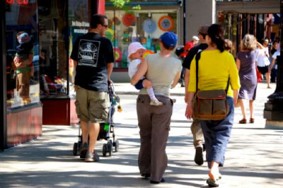 A busy commercial street in Ann Arbor, Michigan emphasizes pedestrian use and provides attractive areas for people to sit, stroll, and meet.
Walking rates in different neighborhoods within the same city are directly related to the quality of the system. In other words, in high-quality pedestrian environments, lots of people walk. Where the system fails—lack of safe crossings, gaps in sidewalks, and other major barriers—people walk less, and those who do walk are at greater risk.
People also want to walk in an environment that is open and inviting where they can feel safe, not only from motor vehicle traffic, but confident in their personal security. It is important to have a well-lit, secure, and pleasant walking environment to encourage people to walk both day and night.
Facilities should be accessible to pedestrians of all ages and abilities. Accessible design is the foundation for all pedestrian design and facilities need to be planned, designed, operated, and maintained to be usable by all people. Poor accessibility may create significant barriers to travel. For example, wheelchair users may use the street if the sidewalk is poorly-maintained sidewalk or lacks curb ramps.
Some populations may be at a higher risk of pedestrian crashes. Children under age 15 are the most overrepresented group in pedestrian crashes and people over age 65 have the most pedestrian fatalities. Therefore, it is especially important to provide adequate facilities in the vicinity of land uses such as retirement homes and school zones. It is important to keep in mind that children and the elderly are part of every community. Additionally, almost all of us will experience a disability (even if temporary) at some point in our lives, so adequate facilities are needed everywhere people are expected to walk.
Walkable design and pedestrian safety begin by thinking about how people use public spaces, including streets, to logically connect destinations within a project, community, campus, city, etc. Some of the questions to consider in almost any context include:
- Are there significant obstacles to walking, such as extended gaps in the pedestrian network?
- Are there places for people to cross roads safely?
- Is there a major road that separates a residential neighborhood from a commercial district?
- Â Are there continuous walkways?
- Are there physical barriers such as rivers, drainage ways, walls, or freeways that prevent convenient walking access in a community?
- Do bridges provide a safe walking area for pedestrians?
- Does the lack of curb ramps or the existence of steep grades or steps prevent access for the elderly or people using wheelchairs?
- Are there information barriers preventing people with visual disabilities from crossing the street?Â
- Do streets provide consistent pedestrian facilities, meeting at least minimum standards for each facility?Â
Streets: The Arteries of Life
Streets serve many functions, including:
- Regional Connectivity – they connect cities and parts of cities to each other, supporting personal, commercial, societal, and governmental needs for efficient transport.
- Transportation – they provide the surface and control mechanisms for a variety of transportation modes, including pedestrians, bicyclists, transit, motor vehicles, emergency services, maintenance services, and freight, among others.
- Access – they provide public access to adjacent public and private property.
- Public right-of-way – they serve as corridors for public utilities and other underground infrastructure.
- Sense of place – the street is a definable place, a place for people to interact, the heart of a community. A street can also serve this role by being a venue for parties, fairs, parades, and community celebrations, or by simply being a place where neighbors stop to chat.
Streets are often designed to emphasize some particular functions over others. At one extreme is a limited-access highway that serves as a corridor for motor vehicle travel, often prohibiting non-motorized modes. At the other extreme is a private cul-de-sac, which has no linkage and limited access. Many streets have been designed in a way that either purposefully or neglectfully limits certain desirable functions. Examples include commercial streets that limit driveway access to destinations in order to minimize traffic congestion or conflicts and strip development along high-speed arterial roads where no sidewalks or pedestrian crossings exist.
When streets and roads are evaluated for improvements, it is helpful to consider whether the design effectively meets all the desired functions of the roadway. If not, methods should be considered to adequately meet those functions.
How Pedestrians are Affected by Traffic: Traffic Volume and Speed
Pedestrian injuries are less frequent and less severe on roadways with lower speeds. The arterial street shown in the two photographs below is located in one of Seattle, Washington’s thriving residential neighborhoods. Â High vehicle speeds and concerns about pedestrian safety when the street operated with the geometric configuration shown in the top photo resulted in the redesign shown in the “after” condition (bottom) photo. Bike lanes and automobile lane reductions (from four lanes to two lanes) have encouraged slower traffic speeds. According to FHWA’s Evaluation of Lane Reduction “Road Diet” Measures on Crashes, such traffic calming measures as those introduced in Seattle can reduce vehicle speeds by 4-5 mi/h (11.27 km/h).6
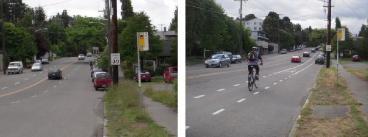 High vehicle speeds and concerns about pedestrian safety when the street operated with the geometric configuration shown in the top photo resulted in the redesign shown in the “after” condition (bottom) photo. Bike lanes and automobile lane reductions (from four lanes to two lanes) have encouraged slower traffic speeds.
High volumes of traffic can inhibit a person’s feeling of safety and comfort and create a “fence effect” where the street is almost an impenetrable barrier. The effect of traffic volumes on community life has been measured. In his seminal 1980 study, Donald Appleyard looked at how traffic volumes on comparable streets in San Francisco, California affected community life. People living on a street with light traffic (2,000 vehicles per day) had three times as many friends and twice as many acquaintances on the street as did people living on a street with heavy traffic (16,000 vehicles a day).7
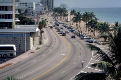 This roadway acts as a barrier to pedestrians. Pedestrians may find it difficult to cross due to its width, traffic, and lack of crossing areas.
Managing traffic speed is an important aspect of walkability and safety. Pedestrians may feel comfortable on streets that carry a significant amount of traffic at low speeds than they do on streets with higher speeds as faster speeds increase the likelihood of pedestrians being struck. At higher speeds, motorists are less likely to see and appropriately react to a pedestrian. At 31 mi/h (49.9 km/h), a driver requires about 200 ft (61 m) to react and stop; that distance is halved at 19 mi/h (30.6 km/h).8
Many streets serving a variety of modes carry traffic that travels at speeds that are incompatible with safe pedestrian activity. Reducing vehicle speed should include an approach that considers engineering, enforcement, and education measures. The safety benefits of reduced speeds not only include pedestrians but also extend to motorists and cyclists, as well, although the advantage to pedestrians is the most substantial from an injury and fatality standpoint.
Pedestrians and Transit
Walking and transit are complementary. Good walking conditions for pedestrians are important to support public transportation, since most public transit trips include a pedestrian trip at one or both ends. People should be able to walk to a transit stop from their homes and to jobs, shopping, and other activities. Frequent and reliable public transportation strengthens and benefits the development of walkable communities. A walking trip to transit should be as seamless as possible and transit stops should be friendly, comfortable places. Among a variety of issues, consideration needs to be given to the location of bus stops relative to intersections, how to get transit users safely across the street, providing adequate space for boarding and disembarking (including disabled riders), and accessibility between stops and nearby destinations.
Development tends to increase pedestrian activity and support expanded transit facilities and service. The integration of appropriate and adequate pedestrian facilities at transit stops is critical to enabling access, supporting ridership, and enhancing a multi-modal environment. Several resources published by the Institute of Transportation Engineering (ITE) and the American Public Transportation Association (APTA) provide guidance regarding appropriate design of pedestrian facilities within the transit environment.
Providing Accessibility for All
The Americans with Disabilities Act (ADA) was enacted in 1990 to ensure people with disabilities have equal opportunities and access to public spaces. People with disabilities may have diminished mobility, limited vision or hearing, or reduced cognitive skills. In some instances, individuals may experience a combination of disabilities and as people grow older their abilities typically diminish.
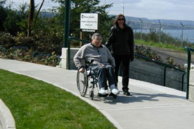 Facilities that accommodate people with disabilities improve the walking environment for all pedestrians.
A person may experience a disability on a permanent or temporary basis. Without accessible pedestrian facilities, people with disabilities will have fewer opportunities to engage in employment, school, shopping, recreation, and other everyday activities along with possibly experiencing fewer housing options. New or altered facilities must provide access for all pedestrians. While improvements for persons with disabilities were mandated by the federal government to ensure access and mobility for physically-challenged pedestrians, most of these improvements benefit all pedestrians. Some of the strategies presented in this guide, such as adequate time to cross streets; well-designed curb ramps; access management; and sidewalks that are wide, clear of obstructions, and have minimal cross-slope, are examples of design features that will accommodate pedestrians with disabilities, persons using walkers, mobility devices such as scooters and wheelchairs, strollers, and, indeed, all pedestrians.9
All new construction or retrofit projects must include curb ramps and other accessible features that comply with ADA requirements. Agencies should review their street system to identify other barriers to accessibility and prioritize the needed improvements. This review is a requirement of the Rehabilitation Act of 1973 and the ADA. States, cities, and other localities are required to develop an inventory of public rights-of-way facilities (e.g., sidewalks and curb ramps – usually referred to as a “self-evaluation plan”) and an ADA transition plan that includes a schedule for removing barriers on existing pedestrian facilities. According to federal regulations, the barriers should have been removed by 1995. Examples of barriers include poles and signs obstructing the sidewalk, steeply sloped driveways along sidewalks, and interruptions such as broken or missing sidewalk sections. An adequate level of surveillance and maintenance is also important to providing accessibility, especially in winter months in areas where snow and ice accumulate. While all streets should be accessible, public agencies should set priorities for high-use areas, such as commercial districts, schools, parks, transit facilities, etc., along with government buildings, such as courthouses, and retrofit as rapidly as possible.
The design criteria for the construction and alteration of facilities covered by law were developed by the U.S. Access Board and are known as the ADA Accessibility Guidelines (ADAAG). These guidelines serve as the basis for standards that are maintained by the U.S. Department of Justice and the U.S. Department of Transportation and are the minimum criteria for designing public right-of-way space. In addition, on July 26, 2011, the U.S. Access Board released proposed guidelines for public comment. This proposal incorporates feedback from the public on previous drafts of the guidelines and will supplement ADAAG. A draft version of these guidelines is available at http://www.access-board.gov/guidelines-and-standards. For the latest ADAAG information and guidance on ADA requirements and issues, visit http://www.access-board.gov.
Walking and Public Health
Public health and medical professionals have long recognized the health benefits of walking. The Centers for Disease Control and Prevention (CDC) recommend that adults ages 18 and up get 150 minutes of moderate-intensity exercise throughout the week in order to reduce the risk of chronic health conditions such as heart disease, Type-II diabetes, and some cancers. Brisk walks of as short as ten minutes help contribute to this overall goal. Walking requires no special equipment, is low impact, and can be done at any age. Other health benefits of walking include weight management, increased bone and muscle strength, improved mental health and mood, and increased coordination. As the focus shifts from the treatment to the prevention of disease, public health and medical professionals promote regular walking as an accessible and easy way to improve not just current but future well-being. Planners, engineers, and other practitioners and decision-makers can support these efforts by making pedestrian environments that are safer and more pleasant for walking.
Funding
Pedestrian projects and programs can be funded by federal, state, local, private, or any combination of sources. A summary of federal pedestrian funding opportunities can be viewed at
http://www.fhwa.dot.gov/environment/bicycle_pedestrian/guidance/bp-guid.cfm#bp4. There are several funding programs that local governments may pursue:
- Federal Transportation Sources
- Congestion Mitigation and Air Quality Improvement Program (CMAQ) funds may be used for projects that demonstrate an air quality benefit within air quality nonattainment areas.
- Highway Safety Improvement Program (HSIP) funds may be used for pedestrian projects aimed at increasing safety and reducing crashes and fatalities, with no location restrictions.
- National Highway Performance Program (NHPP) funds may be used for pedestrian projects that benefit National Highway System corridors.
- Surface Transportation Program (STP) funds may be used for any pedestrian facility, with no location restrictions. Any project eligible under the Transportation Alternatives Program or Recreational Trails Program (described below) also is eligible under STP.
- Transportation Alternatives Program (TAP) funds may be used for any pedestrian facility, with no location restrictions. They may also be used to correct facility deficiencies that have been identified in a public entity’s ADA transition plan; as long as those scheduled corrections are part of a larger project. Projects must be sponsored by eligible entities. Any Safe Routes to School project and any project eligible under the Recreational Trails Program (RTP) also is eligible under TAP.
- Recreational Trails Program (RTP) funds may be used for any kind of recreational trail. In most States, the RTP is administered through a State resource agency, not the State DOT.
- See a comprehensive list at http://www.fhwa.dot.gov/federalaid/projects.cfm.
- Other Funding Sources
- The Catalog of Federal Domestic Assistance has a variety of possible Federal funding sources.
- Some States may have State funding programs for pedestrian facilities.
- Funding for encouragement and safety education could be derived from employer contributions to transportation demand management (TDM) programs, partner organizations, and CMAQ funds.
- Local governments should consider funding stand-alone projects through a combination of general funds, developer contribution and impact fees, bonds, etc., to address pedestrian safety and facility discontinuity resulting from intermittent redevelopment of roadside property.
- Information Resources
- A Guide to Transportation Decisionmaking: The Federal Highway Administration (FHWA) and Federal Transit Administration (FTA) created A Guide to Transportation Decisionmaking to answer transportation project-related questions.

